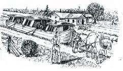
Wabash & Erie Canal, 1832–1874
On March 2, 1827, Congress provided a land grant to encourage Indiana to build the Wabash & Erie Canal. The original plan was to link the navigable waters of the Maumee River with the Wabash River through the seven-mile portage at Fort Wayne.
Construction began on February 22, 1832, in Fort Wayne and proceeded westward. The canal reached Huntington by 1835, Logansport in 1838, and Lafayette in 1841. Work also extended east toward Ohio, although the canal did not open to Toledo until 1843. A second federal land grant enabled the canal to reach Terre Haute by 1849.
At Evansville, 20 miles of the Central Canal had been completed northward by 1839. During the late 1840s, the Wabash & Erie was extended south through the abandoned Cross-Cut Canal works to Worthington, then followed the previously proposed Central Canal route. The connection with the Evansville segment was completed in 1853, forming the longest canal in the United States.
By 1860, portions south of Terre Haute had closed, and decline continued northward. In 1876, the canal was auctioned by its trustees. Read more about the canal.
